Four-wheeling in the Central Colorado Rocky Mountains is not just four-wheeling…
It is a memorable adventure into the celebrated backcountry where high mountain lakes sparkle in the Colorado summer sun and clear streams rush down steep, rocky terrains. It is a drive past the timberline to lofty heights that offer stunning vistas, leaving you breathless in every sense of the word. It is a journey into the wild and beautiful, and a step back in history to an era of frenzied prospecting and booming mining towns. The ghosts of these once bustling places remain.
The Rocky Mountain backcountry in the Salida area is vast and rugged. It only makes sense, then, to get the most out of your trip to this area by exploring it on a four-wheeler. Whether you drive your own four-wheeler, rent a vehicle, or take a four-wheel drive tour, you can expect no less than a thrilling experience. The Salida/Buena Vista Area provides numerous trails with amazing views of the Sawatch Range and Sangre de Cristo mountain ranges as well as fascinating ghost town and mining districts to explore.
Here are directions to some trails for your four-wheeling adventure in the Colorado Rocky Mountains:
Go west of Nathrop on CR 162 for about 10 miles to Alpine. Take CR 293 and proceed up this 9-mile road. The road is extremely narrow with difficult water crossings and dangerous switchbacks and is thus recommended for experienced drivers only.
Take CR 162 past St. Elmo on the Chalk Creek Road. The pass reaches 12,000 ft. and runs a distance of about 9 miles in length. The surface is poor and is recommended for experienced drivers only.
Crosses the Sangre de Cristo mountain range southeast of Salida, and is one of very few crossings of those mountains. Take US Hwy 50 to Coaldale, go up Hayden Creek Road to the pass turn-off. The 7-mile-long road is narrow with a poor surface. Sections of the roadbed are unstable; in the spring, the road is often clogged with winter avalanche debris. Once at the top of the pass, you will see a magnificent view of the Sangre de Cristo range and the San Luis Valley. The western end of the road is in Villa Grove in the San Luis Valley.
What you will see: Continental Divide, alpine scenery, network of 4WD trails, rocks, minerals
Difficulty: Challenging
Driving Time: 1.75 hrs. one-way
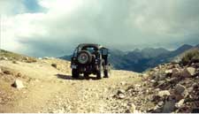
The Mount Antero Route begins at the intersection of CR 162 and FR 277, Baldwin Creek Road, 12 miles west of US Hwy 285. Very rough and rocky, the road is extremely narrow in spots with difficult water crossings and dangerous switchbacks. The first 2 miles are the most difficult and are essentially a rough, rocky shelf road through pine and aspen forest. The track is narrow and has steep drop-offs. At mile 2.7 you will cross Baldwin Creek, running at a foot of water or less, typically. The next section of the road climbs through talus slopes and then emerges above timberline. A series of narrow switchbacks at this point impedes passing. An intersection at the 3.8 mile point provides the last opportunity to turn around before the road’s end. The right hand track is a dead end. Walk the last half-mile.
What you will see: St. Elmo, Hancock, and Romley; summit view of Brittle Silver Basin; network of 4WD trails; hiking trail to eastern portal of Alpine Tunnel
Difficulty: Moderate
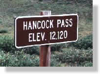
Hancock Pass was a mining route in the 1880s but was not significant commercially. Much of the route on the eastern side of the pass follows the Denver, South Park & Pacific Railway grade toward the Alpine Tunnel.
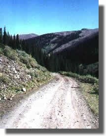
Take CR 162 past St. Elmo on the Chalk Creek Road. It reaches 12,000 ft. and is 9 miles long. The surface is poor and is recommended for experienced drivers only. The route passes the old townsites of Romley, a mining camp for the nearby Mary Murphy Mine, which was the primary supporting mine for the St. Elmo township. Hancock was a construction town for the railroad workers who built the Alpine Tunnel from 1880-1882. Romley is located about 2.5 miles from St. Elmo. Just past Romley is the turnoff for the Pomeroy Lakes Road. At mile 4.8 you will see a precariously supported building perched to the side of the road. This building was the storage place for ore from the Allie Belle Mine. Above the structure are several other mine buildings. Just beyond is the last remaining building of the Hancock site, the collapsed timbers of the town saloon. A parking lot marks the beginning of the hiking trail to the Alpine Tunnel. Immediately after the parking lot, you will find an intersection. Take the right road to continue on the trail to Hancock Pass. Veer left to a 1.4 mile road to Hancock Lakes trailhead. Walk one-half mile along this trail to the Hancock Lakes.
This part of the road marks a more difficult ascent and is meant for 4WD only. At the summit of Hancock Pass you will see an awesome view of Brittle Silver Basin. The road descends into Brittle Silver Basin the last mile and it can be difficult to get traction on the loose rock on the last hundred yards.
What you will see: Historic towns of St. Elmo and Tin Cup, summit views, Mirror Lake, back country campsites
Difficulty: Easy but very rough, 12 miles
First used by Indians and then as a pack trail, the Tin Cup Pass Road was established in the 1870s and was originally used to move supplies between St. Elmo and the town of Tin Cup. When trains came to the mining towns, none came to Tin Cup. However, there was a train that came to St. Elmo. There was a need to get ore, people and supplies between both cities—Tin Cup pass was used every day of the year during the early part of the 1880s for that purpose. In 1881, it became a toll road and three stage lines were running daily routes over the pass. During WWI, the road was used to train the cavalry.
Take CR 162 at St. Elmo. Initially the road climbs toward the pass following the North Fork of Chalk Creek. The surface of the road is poor, very rocky, and narrow in places as it winds through old mining areas, back country campsites and across the Continental Divide. The view from the summit is spectacular with panoramas of the Arkansas River Valley and Taylor Park. As the road travels west of the summit, it skirts Mirror Lake, a popular fishing spot.
If you want a full day trip, take CR 306 for an 18-mile trip to Cottonwood Pass through scenic areas. Proceed west over the pass about 15 miles father into Taylor Park country. At the Taylor Reservoir, turn left and proceed south 10 miles to the village of Tincup. In Tincup, turn left and head east, passing Mirror Lake.
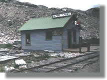
What you will see: Alpine Tunnel Station, old railroad grade, railroad water tanks, town sites of Woodstock and Quartz
Difficulty: Easy
Teams of workers on both sides of the Alpine Tunnel started digging and blasting with the intent of connecting St. Elmo to Pitkin via a rail line in November 1879. This area looked as though it was going to be very profitable so the railroad felt this would be a successful expansion. Approximately 350 workers on one end, and 400 workers on the other, labored through nasty winters and summers until July 1881 when the two crews met each other in the tunnel. The length of the Alpine Tunnel is 1771.7 ft. long within the mountain. The headings were off by only 11/100th of a foot, amazingly accurate considering that it was a blind bore, on a curve laid to opposing grades. An engineer’s drawing stored in the restored Station validates the accuracy of the job.
The route begins at the old Quartz townsite, 3 miles northeast of Pitkin on the Cumberland Pass Road (FR 765) at the Alpine Tunnel Road turnoff (FR 839). Remains of the Old Midway water tank lie 3 miles along the route. This was the halfway point between Pitkin and the Alpine Tunnel. Two miles further is the restored Tunnel Gulch water tank.
The Mile High Jeep Club is gradually restoring many old buildings and relics in the area. The route continues past the site of Woodstock which was totally wiped out by a snowslide in 1884, killing 13 people. The remnants of the old Woodstock water tanks remains. You will pass the Sherrod Loop which is marked by an information board. This loop enabled the trains to turn and remain on the sunnier south side of the valley. The Palisades (11,300 ft.), a man-made terrace, enabled the train to travel along a spectacular, steep cliff face. Hand-cut stones, dry stacked 33 ft. high and 425 ft. long, supported the ledge.
What you will see: Scenic high country lake, Mt. Antero network of 4WD road.
Difficulty: Moderate, some narrow switch-backs, loose rock and some tight clearances
The trail begins at the intersection of Mt. Antero road (FR278.A) and Brown’s Lake Road (FR 278.2). Proceed along the road into the valley. At 1.9 and 2.0 miles you will see cabin ruins on the right and left, respectively. At 2.5 miles, cross Brown’s Creek. The road ends at mile 3.3 at the Brown’s Creek Trailhead.
This road is less traveled than the Mt. Antero Road. It travels through Brown’s Creek Valley, enters timberline where the track can get quite narrow through the pine trees. At the end of the road you will enjoy picture-postcard views of Brown’s Lake at an altitude of 11,286 ft.
What you will see: Mary Murphy Mine ruins, a short but challenging 4WD trail, Pomeroy Lakes
Difficulty: Challenging but short, requires high clearance 4WD vehicle
The Mary Murphy Mine was discovered in the mid-1880s and was active until 1926. The mine was tremendously successful and was the chief economic vehicle for the towns of St. Elmo, Romley, and Hancock. When it closed, the area died with only a few hardy souls remaining in St. Elmo.
Begin on the road to Hancock that follows the Alpine Tunnel grade. Turn onto FR 297 and pass through the remains of the Mary Murphy Mine. You will see the remains of old tramway towers which extended into Pomeroy Gulch. Also, there are a number of buildings where the tramway deposited ore. You will pass numerous backcountry camp sites.
As the road approaches the lake, it becomes more rutted and eroded. There is a parking area near the lakes, 2.7 miles from the start.
What you will See: Network of 4WD trails, scenic alternative to Hwy 50
Difficulty: Easy for passenger cars, road is graded and wide
The discovery of gold and silver on both sides of Monarch Pass lead to the establishment of several towns including Maysville, Garfield (Junction City), and Monarch (Chaffee City). The Denver & Rio Grande Railroad built a spur line from Salida to Monarch that operated until 1982. A stage route traveled the old route on an old wagon road which is now closed to 4WD traffic. In 1939 the present Hwy 50 route over Monarch Pass was completed.
From Hwy 50, turn onto Monarch Pass Road (FR 237) 1 mile east of the present summit.
What you will see: Historic Tincup, Tincup Boothill (boothill refers to graveyards of gunfighters who ‘died with their boots on’), panoramic views, Bon Ton Mine
Difficulty: Moderate to easy
Cumberland Pass is one of Colorado’s most historic passes and one of the highest 2WD roads in the US. The main road was built in 1882 as an upgrade to a more primitive pack trail. Until the construction of this road, most of Tincup’s supplies came across at Cottonwood Pass. At Tincup, take the Cumberland Pass Road (FR765). The turnoff from the main Cumberland Pass road at the 0.3 mile point is unmarked on the left.
The road passes abandoned mines, mining camps and cabin ruins on its journey to the pass. Above timberline, panoramic views lure you on as the road progresses. There are many 4WD pathways here and you must be careful to stay on the right track. At the summit, you will see the magnificent Sawatch Range to the east with the Elk Mountains to the west. The descent toward Pitkin is an easy 2WD road passing through the old Bon Ton Mine site. Five miles distant is the Alpine Tunnel turnoff.